Tocht Stappen La Chapelle-Gauthier - Boucle des Gauthiers - La Chapelle Gauthier - Photo

Boucle des Gauthiers - La Chapelle Gauthier

 tracegps
tracegps

Gebruiker

© OpenStreetMap contributors
Lengte
Lengte
15,9 km
Max. hoogte
Max. hoogte
201 m
Positief hoogteverschil
122 m
Km-Effort
Km-Effort  
17,6 km
Min. hoogte
Min. hoogte
134 m
Negatief hoogteverschil
121 m
Boucle
Boucle
Ja
Datum van aanmaak :
2014-12-11 00:00:00.0
Laatste wijziging :
2014-12-11 00:00:00.0

(0 Bericht)

Stappen
Stappen
1h00
Moeilijkheid : Medium

Scan deze QR-code om de tocht te openen in de SityTrail-applicatie

Gratisgps-wandelapplicatie

Logo SityTrail SityTrail

IGN / Geografische instituten

SityTrail uit de App Store downloaden SityTrail uit Google Play downloaden

Logo SityTrail SityTrail World

De wereld gaat voor u open

SityTrail uit de App Store downloaden SityTrail uit Google Play downloaden SityTrail op Huawei AppGallery downloaden

Over ons

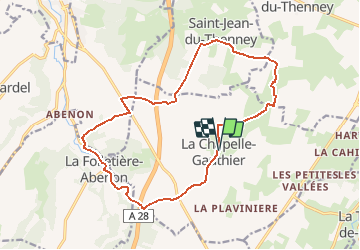
Tocht Stappen van 15,9 km beschikbaar op Normandië, Eure, La Chapelle-Gauthier. Deze tocht wordt voorgesteld door tracegps.

Beschrijving

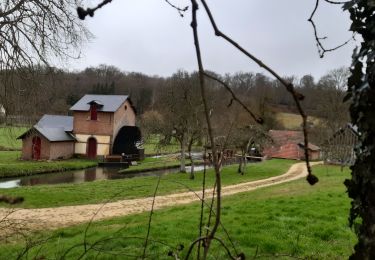
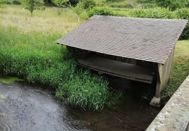
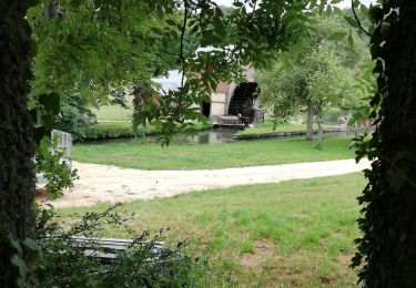
Circuit proposé par la Communauté de Communes du canton de Broglie. Départ de la mairie de La Chapelle-Gauthier. Ce circuit a été numérisé par les randonneurs du CODEPEM. Merci à Jean-Marie.

Hoogteprofiel

Plaatsbepaling

Land:
France
Regio :
Normandië
Departement/Provincie :
Eure
Gemeente :
La Chapelle-Gauthier
Locatie:
Unknown
Vertrek:(Dec)
Vertrek:(UTM)
314368 ; 5429094 (31U) N.

Wandeltochten in de omgeving

Tocht Stappen La Chapelle-Gauthier - La Mare Péreuse - La Chapelle-Gauthier - Photo
Stappen
tracegps

Stappen

Medium
La Chapelle-Gauthier, Normandië, Eure, France
10,3 km | 11,9 km-effort
2h 45min
Ja
Tocht Fiets Broglie - Boucle des 3 Maréchaux  -  Broglie - Photo
Fiets
tracegps

Fiets

Medium
Broglie, Normandië, Eure, France
18,5 km | 20 km-effort
1h 15min
Ja
Tocht Stappen Broglie - Circuit du Prieuré - Broglie - Photo
Stappen
tracegps

Stappen

Moeilijk
(1)
Broglie, Normandië, Eure, France
13,2 km | 14,9 km-effort
3h 19min
Ja
Tocht Stappen Saint-Aubin-du-Thenney - boucle de St Aubin  - Photo
Stappen
ymarvin

Stappen

Gemakkelijk
Saint-Aubin-du-Thenney, Normandië, Eure, France
5,2 km | 5,7 km-effort
1h 1min
Ja
Tocht Stappen Broglie - Broglie - Photo
Stappen
werth

Stappen

Medium
Broglie, Normandië, Eure, France
10,1 km | 11,8 km-effort
2h 50min
Ja
Tocht Stappen La Trinité-de-Réville - la trinite de Reville  - Photo
Stappen
ymarvin

Stappen

Medium
La Trinité-de-Réville, Normandië, Eure, France
9,8 km | 12 km-effort
2h 3min
Ja
Tocht Stappen Broglie - autour de Broglie - Photo
Stappen
ymarvin

Stappen

Heel gemakkelijk
Broglie, Normandië, Eure, France
8,6 km | 9,6 km-effort
1h 45min
Ja
Tocht Stappen Saint-Aubin-du-Thenney - Saint aubin du thenney - Photo
Stappen
ymarvin

Stappen

Heel gemakkelijk
Saint-Aubin-du-Thenney, Normandië, Eure, France
7,8 km | 8,6 km-effort
1h 42min
Ja
Tocht Stappen La Vespière-Friardel - La Vespiere  - Photo
Stappen
Eve - Line

Stappen

Medium
La Vespière-Friardel, Normandië, Calvados, France
22 km | 27 km-effort
4h 22min
Ja


Sluiten
Mijn abonnementen